Hello and Welcome,
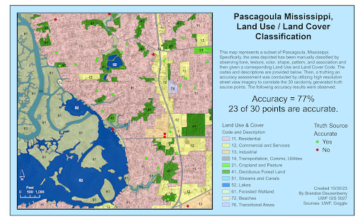
This week covered two interrelated topics. Land use and land cover, and assessing accuracy or truthing for the same. The combined result of which is displayed below. So what happened?
First, with only an image of the Pascagoula area of Mississippi, and a basic understanding of Land Use and Land Cover classification, I digitized the entire image area according to my visual inspection of the land use or cover elements present. Utilizing the tone, texture, shape, size, color, patterns, and associated elements that we discussed last week, I went through and identified the uses of these areas and then gave them the corresponding code, down to the 2nd level of classification. for example, I identified residential areas, but did not sub divide into single unit or multi-unit dwellings. Or, as another, streams and canals were identified, but not specifically, rivers, creeks, rivulets, manmade or natural, etc.
Then, after the entire image was classified according to my visual inspection, I utilized a random point generator to create markers for truthing. Because I could not physically go to Pascagoula and these sites, I utilized Google Street View, in place of an in situ investigation. The sample size was kept at an easily manageable level, only 30 points for training purposes, despite Jensen suggesting a minimum of 50. But for training purposes this allowed me to break out a couple of good datapoints.
There was an overall accuracy of 77% as depicted below, just based on the points used. But some categories like the residential category show in excess of 89% accuracy sense more points were in that category and they appeared to be relatively more accurate. But at the same time, with the random sampling technique, not all categories were included. That is one area for improvement for future truthing, ensuring all categories are sampled.
Above you can see the different usage and cover categories that make up the picture, as well as the truthing points. With more time, we would see a continued expanding of the Land Use / Cover Cateogries, but more specifically, further subdividing into 3rd level categories which would provide a larger nuance to the classification presented here.
Thank you.
v/r
Brandon


No comments:
Post a Comment